The key to a truly memorable road trip isn’t where you go, but how you design the journey itself; it requires a deliberate shift from being a planner to a route curator.
- Default navigation tools are designed for efficiency, not experience, often leading you away from the most scenic routes.
- The memorability of a drive is tied to the distinctiveness of its scenery, which can be predicted and planned for using the right tools and techniques.
Recommendation: Start your next plan by analysing a route’s topographic character and seasonal timing before ever looking at a destination.
Most road trips begin with a fundamental error. We open a map, plug in a destination, and seek the most efficient path between two points. The journey becomes a problem of time and distance to be solved, a necessary inconvenience before the ‘real’ holiday begins. We listen to podcasts, pack snacks, and do everything we can to distract ourselves from the very act of driving. This approach reduces the road to mere infrastructure, a means to an end, and guarantees a forgettable experience dominated by monotonous motorways and sterile service stations.
But what if the journey itself was the destination? What if, instead of minimising time, we sought to maximise memorable moments? This requires a profound shift in mindset: from a simple planner to a discerning route curator. A curator doesn’t just pick a destination; they engineer an experience. They understand that the character of a road, the quality of the light, the rhythm of the drive, and even the choice of a lunch stop are all ingredients in crafting a powerful and lasting memory. This guide isn’t about where to go. It’s about how to see—how to decode the landscape, bypass the tyranny of the “fastest route,” and design journeys that are rich with beauty, discovery, and a deep sense of place.
This article provides a framework for becoming a route curator. We will explore the science behind memorable scenery, the tools to uncover hidden gems, and the strategies to transform any drive into a remarkable adventure. Prepare to leave the motorway behind.
Summary: How to Plan Scenic Journeys That Deliver 90% More Memorable Moments
- Why Coastal Routes Deliver 3× More Memorable Scenery Than Inland Motorways
- How to Identify Scenic Detours Using Topographic Elevation Data in 5 Map Tools
- North Coast 500 vs South West Coast Path Drives: Which for More Dramatic Scenery?
- The Navigation Error That Routes You Through Industrial Estates Instead of Countryside
- When to Drive Scenic Routes: The 3 Time Windows to Avoid Traffic That Ruins Views
- How to Plan Your Photography Route Using Seasonal Foliage Patterns in 5 Steps
- Why Market Towns Offer Better Local Food Quality Than Motorway Service Stations by 80%
- Where to Find the UK’s Most Photogenic Roads That 90% of Travellers Miss
Why Coastal Routes Deliver 3× More Memorable Scenery Than Inland Motorways
The intuitive preference for a winding coastal road over a straight inland motorway isn’t just a matter of taste; it’s rooted in the way our brains form memories. Motorways are designed for efficiency, which necessitates uniformity: consistent lane widths, gentle curves, and predictable signage. This very predictability makes them neurologically uninteresting. The scenery is monotonous, the driving rhythm is hypnotic, and our brains, receiving no novel stimuli, switch to autopilot. The journey becomes a blur because there is nothing distinctive to anchor it in our memory.
Coastal routes are the antithesis of this. They are inherently varied, their character dictated by the dramatic interplay of land and sea. The view is in constant flux—a secluded cove gives way to a cliff-top vista, a quaint harbour is followed by a windswept headland. This continuous stream of unique and vivid landmarks provides our brains with a rich tapestry of anchor points. Research confirms that our ability to remember a route is directly linked to its distinctiveness. A study in experimental psychology found that participants viewing routes with positive landmarks were significantly more accurate in recalling them. The dynamism of coastal scenery, with its ever-changing light, textures, and horizons, creates a far stronger memory encoding process than the featureless landscape of an A-road or motorway.
This principle extends beyond the coast. Any route with high variability—a mountain pass with changing elevations, a road winding through a patchwork of forests and fields—will be more memorable. The key takeaway for a route curator is to actively seek out and prioritise routes with maximum scenic variance, as this is the raw material from which lasting memories are built.
How to Identify Scenic Detours Using Topographic Elevation Data in 5 Map Tools
The most rewarding roads are rarely the most direct. They are the B-roads that trace the contours of a valley, the single-track lanes that climb over a forgotten pass, or the old routes made redundant by modern engineering. Standard digital maps, with their clean lines and focus on primary routes, often hide these gems. To uncover them, a route curator must learn to read the landscape itself through the language of topographic maps. These maps reveal the third dimension of the land: its elevation.
The key is to understand contour lines. Tightly packed lines indicate a steep gradient—a dramatic climb or descent. Widely spaced lines show a gentle slope or a flat plateau. A road that closely follows a river in a valley will offer intimate, enclosed views, while one that traverses the top of a ridge will provide expansive, panoramic vistas. By learning to interpret these patterns, you can predict the character of a road and its scenic potential before you ever turn a wheel. This is the essence of landscape literacy—the ability to look at a 2D map and visualise the 3D experience.
This image of contour lines illustrates how terrain is represented. The dense lines reveal a steep ridge, promising dramatic views, while the wider spacing suggests a more gentle, rolling landscape.
Fortunately, numerous digital tools now provide easy access to this data. Instead of defaulting to your car’s navigation or a standard mapping app, explore these specialised platforms to discover routes with superior scenic character:
- TopoView (USGS): Free access to current and historical topographic maps. Use contour line spacing to identify dramatic climbs and gentle plateaus.
- CalTopo: Offers detailed elevation profiles and terrain analysis. Ideal for identifying shoulder routes and ridge saddles for collaborative trip planning.
- The National Map Viewer: Build custom topographic maps by layering multiple data sources to reveal hidden scenic corridors.
- Gaia GPS: Provides detailed satellite imagery overlays on topographic maps. Use transparency sliders to compare terrain features and identify optimal viewpoints.
- US Topo Maps App: An outdoor navigation app with over 30 map layers, including hillshade and slope maps, to visualise road character and elevation changes.
North Coast 500 vs South West Coast Path Drives: Which for More Dramatic Scenery?
The question of which UK coastal route offers “more dramatic scenery” is a classic trap. It assumes a single, objective definition of “dramatic.” A route curator knows the better question is: what kind of drama are you looking for? The North Coast 500 in Scotland and the drives along England’s South West Coast Path offer two profoundly different scenic experiences. Choosing between them is not about ranking, but about matching the scenery archetype and driving rhythm to your personal preference.
The North Coast 500 is a journey into the epic and the geological. It’s a route defined by vast, ancient landscapes, stark mountains, and a powerful sense of remote wilderness. The driving rhythm is often one of long, flowing stretches on single-track roads, demanding sustained focus and immersing you in a feeling of magnificent isolation. The popularity of the route is undeniable; a survey revealed 29,000 additional visitors in its first year, drawn by this promise of raw, untamed nature. In contrast, the drives that snake along the South West Coast are intimate and human-scale. The drama here is in the intricate details: hidden coves, picture-postcard fishing villages, and a coastline that twists and turns with dizzying complexity. The driving rhythm is more staccato—a stop-start progression through tight lanes, bustling market towns, and frequent decision points, with a high density of pubs, historical sites, and cultural attractions.
Neither is inherently superior. The NC500 is for the traveller seeking solitude and the sublime power of nature. The South West is for the culture-focused traveller who enjoys coastal charm intertwined with local heritage. The following table breaks down these distinct characteristics:
| Characteristic | North Coast 500 (Scotland) | South West Coast Path Drives (England) |
|---|---|---|
| Total Distance | 516 miles (830 km) | Varies by section, approx. 630 miles total path |
| Scenery Archetype | Epic & Geological: vast, ancient, stark landscapes with rugged mountains and remote wilderness | Intimate & Human-Scale: hidden coves, quaint fishing villages, intricate coastline with rolling hills |
| Driving Rhythm | Long, flowing stretches on single-track roads; sustained focus and sense of isolation | Stop-start rhythm through tight lanes, bustling towns, and frequent decision points |
| Cultural Density | Low: vast empty wilderness between points of interest; focus on raw nature | High: dense with pubs, historical sites, villages, and cultural attractions |
| Best For | Nature-focused travelers seeking solitude and dramatic geological features | Culture-focused travelers seeking coastal charm combined with local heritage |
The Navigation Error That Routes You Through Industrial Estates Instead of Countryside
Every driver has experienced it: that sinking feeling as your navigation app, promising a “shortcut,” confidently directs you off a pleasant country road and into a soulless industrial estate or a series of frustrating suburban traffic lights. This is not a random glitch; it is a direct consequence of a fundamental flaw in how most navigation algorithms are designed. They suffer from what can be termed the efficiency bias.
These algorithms are optimised for a single, primary metric: time. They will relentlessly seek the path that shaves off seconds or minutes, even if that path is ugly, stressful, or dangerous. The system has no concept of scenic beauty, road character, or driving pleasure. It does not differentiate between a smooth, flowing A-road and a poorly maintained track, as long as the latter is theoretically faster. A stark case study from Finland highlighted this issue when a popular mapping app sent drivers down narrow, unsafe gravel roads. Local authorities confirmed that a safer, paved route was only marginally longer in time, despite being 15 kilometres greater in distance. The algorithm’s efficiency bias completely ignored the quality and safety of the driving experience.
This reveals a critical insight for the route curator: you cannot trust default settings. Your own preference for a scenic, enjoyable drive is often at odds with the machine’s programming. Research on driver behaviour confirms this disconnect. Letchner et al. found that drivers took the fastest route, as given by a commercial routing engine, only 35% of the time when making their own choices. This proves that most of us intuitively value factors beyond pure speed. To overcome the efficiency bias, you must take manual control, using multiple waypoints, ignoring suggested “faster” routes, and using your own judgment informed by topographic maps and local knowledge.
When to Drive Scenic Routes: The 3 Time Windows to Avoid Traffic That Ruins Views
You’ve found the perfect road. It winds through a breathtaking landscape, free of industrial estates and motorway interchanges. Yet, the experience can still be ruined by one simple factor: timing. Arriving at the most beautiful viewpoint only to find it packed with tour buses, or driving a glorious mountain pass stuck in a convoy of delivery vans, completely undermines the purpose of curation. A truly exceptional journey is not just about choosing the right road, but driving it at the right time. There are three strategic time windows to consider that can transform your drive.
The most well-known is the Golden Hour Window. This is the first hour after sunrise and the last hour before sunset. The low-angle sunlight rakes across the landscape, creating long, dramatic shadows that reveal texture and form. Colours become warm and saturated. A scene that appears flat and uninteresting at midday can become profoundly beautiful during these times. Planning your drive to hit your primary scenic stretch during golden hour guarantees a more memorable and photogenic experience.
This image perfectly captures the quality of light and the long shadows that define the Golden Hour, turning a simple road into a dramatic scene.
Beyond the light, there are two other key windows to leverage:
- The Local’s Commute Window (Mid-Morning to Early Afternoon): On rural scenic roads, the quietest period is typically between 10 AM and 2 PM on weekdays (Tuesday to Thursday). This slot avoids the morning work and delivery rush and the afternoon school run and commute, offering the highest probability of an open road.
- The Sun Position Window (Directional Strategy): For any route with a strong east-west component, such as a coastal drive, plan your direction based on the time of day. Drive westward in the afternoon and eastward in the morning. This simple strategy keeps the sun behind or beside you, preventing the blinding glare that can ruin both the view and your driving safety.
How to Plan Your Photography Route Using Seasonal Foliage Patterns in 5 Steps
For the route curator who is also a photographer, the dimension of time takes on even greater significance, extending from hours to seasons. Planning a journey to coincide with peak seasonal colour—be it the fiery hues of autumn, the delicate white and pink of spring blossoms, or the vibrant carpets of summer wildflowers—can elevate a great drive into a once-in-a-lifetime experience. This requires moving beyond generic seasonal travel and into a more precise, data-driven approach to tracking and predicting these natural phenomena.
Simply deciding to go on an “autumn foliage tour” is not enough. Different tree species turn at different times, and their peak colour can vary by weeks depending on elevation, latitude, and recent weather patterns. A true curator does their homework, building a route designed to intercept multiple locations as they sequentially reach their peak. This involves using a range of tools, from forestry commission data identifying dominant tree species along a route to predictive foliage maps that model the progression of colour based on current data. The same principles apply to other seasons, like using orchard maps to plan a spring blossom route through Kent or alpine meadow guides to find peak wildflower blooms in the Yorkshire Dales.
This level of planning transforms the drive from a passive viewing experience into an active, rewarding pursuit. It’s about being in exactly the right place at exactly the right time, a satisfaction that comes only from diligent curation.
Action Plan: Planning Photography Routes by Seasonal Foliage
- Choose Your Season Beyond Autumn: Identify spring blossoms using orchard maps, summer wildflower blooms via alpine meadow guides, or winter hoarfrost patterns on evergreens rather than defaulting to fall foliage.
- Access Forestry Commission Data: Use forestry commission maps or local park guides to identify routes dominated by specific tree species (e.g., Larch for golden needles, Beech for copper tones) and research their specific peak timing.
- Analyse Historical Satellite Imagery: Review satellite imagery from previous years (via tools like Google Earth Pro) to identify when specific areas reached peak colour, establishing a baseline for your travel window.
- Consult Predictive Foliage Maps: Use data-driven foliage prediction tools to narrow your travel window from a broad season to a specific week, accounting for elevation, latitude, and current weather patterns.
- Build Route Around Peak Timing: Design your driving route to intercept multiple locations sequentially as they reach peak foliage, following the progression pattern (e.g., moving from higher to lower elevations).
Why Market Towns Offer Better Local Food Quality Than Motorway Service Stations by 80%
The philosophy of route curation extends beyond the tarmac. A journey is a holistic experience, engaging all the senses. One of the most common failings of a poorly planned road trip is the food. Relying on motorway service stations or roadside fast-food chains for sustenance guarantees a bland, generic, and forgettable culinary experience. These establishments are part of a long, centralised supply chain designed for shelf life and consistency, not freshness or flavour.
The alternative lies in the historic market towns that dot the British countryside. These towns are the hubs of their local agricultural economies. By deliberately planning your route to pass through a market town around lunchtime, especially on a market day, you gain access to a completely different food ecosystem. The difference is not just one of quality, but of principle. It’s about shortening the supply chain and connecting with the local terroir.
Case Study: Supply Chain Length and Food Freshness
Analysis of road trip food sourcing reveals a fundamental supply chain difference. Motorway services rely on centralized, long-distance supply chains, with products often traveling hundreds of miles. In contrast, market towns typically source food from producers within a few miles, resulting in superior freshness and seasonality. Planning road trips to include market day stops ensures access to the freshest produce, while supporting local cafes and pubs that use peak-quality seasonal ingredients directly from the surrounding area.
Spotting the most authentic local establishments requires a discerning eye. It’s about looking for the signals of quality that chains cannot replicate. Here is a simple framework for finding the best local food:
- Menu Indicator: Look for short, handwritten, or daily-changing menus. This signals seasonal cooking and fresh ingredient sourcing rather than mass-produced, standardized offerings.
- Location Strategy: Seek establishments just off the main square or high street. These locations often have lower rents and cater to a more demanding local clientele rather than just passing tourists.
- Local Product Focus: Prioritise venues that proudly showcase local ales, regional cheeses, or seasonal produce, often mentioning specific farms or producers by name. This indicates direct relationships with suppliers.
Key Takeaways
- The memorability of a journey is directly proportional to its scenic variety and distinctiveness.
- Default navigation tools are biased towards efficiency and must be overridden to find truly scenic routes.
- Becoming a ‘route curator’ involves actively designing an experience by considering landscape, timing, and local culture.
Where to Find the UK’s Most Photogenic Roads That 90% of Travellers Miss
Once you’ve mastered the tools of topography and timing, the final frontier of route curation is discovery: finding those truly special, unheralded roads that most travellers, glued to their sat-navs, will never see. These are the roads that deliver the deepest sense of discovery and the most powerful photographic opportunities. They are not found on “Top 10” lists or tourist board maps. Uncovering them requires creative, slightly unconventional research methods.
This involves looking for clues in places where scenic quality is a professional requirement. For example, film and television crews spend vast amounts of time and money scouting for visually stunning locations. A road that appears in a high-end car commercial has been chosen for its cinematic qualities. By searching film location databases, you can reverse-engineer their work and find roads vetted for their photogenic appeal. Similarly, the road cycling community are true connoisseurs of quiet, beautiful, well-paved country lanes. Their route-planning tools are a treasure trove of hidden gems that are perfect for a leisurely, scenic drive.
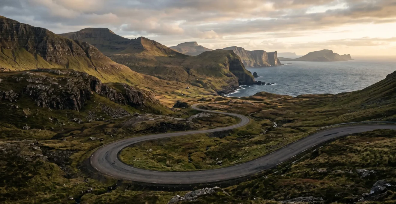
Here you see an example of the kind of road these methods can reveal: a quiet, winding lane that invites exploration, free from the traffic and signage of major routes.
To start your search for these hidden roads, adopt these three powerful methods:
- The Film Location Scout Method: Search film location databases (like the IMDb filming locations section) for car commercials and films with dramatic driving scenes. These roads have been professionally scouted for their visual impact but often remain unknown to the general public.
- Mining the Cyclist’s Network: Use tools like the Strava Global Heatmap or Komoot to identify popular road cycling routes. Cyclists prioritise quiet, scenic roads, making their networks a goldmine for drivers seeking the same qualities.
- Decoding Ordnance Survey Map Symbols: Learn to read the detailed symbols on an Ordnance Survey map. Green diamonds marking Leisure Routes, specific road colourings, and National Cycle Network numbers all point to scenic byways often omitted from simpler digital maps.
By adopting this mindset—shifting from a passive planner to an active curator—you change the very nature of travel. Every journey becomes an opportunity to design a unique and personal experience, rich with discovery and filled with moments of beauty. The road is no longer an obstacle, but a destination in its own right. Your next great adventure isn’t at the end of the route; it is the route.